Text and images by Vincenzo Battista. Originally published in the year 2001.
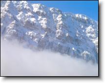
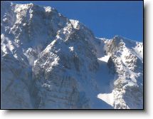
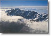
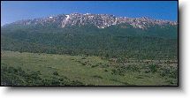
When we came out of the clouds in our two-seat Partenavia P.66, me and pilot Giorgio Zecca, it looked like the plane would almost touch the pinnacles, the deep abyss, the rugged valleys, the carsick peaks, the tops covered in snow and ice on the North-Western side of Mount Sirente (2341 m. above sea level, over 7,000 feet). We were flying above one of the most hidden areas of the Sirente – Velino regional park. We were astounded in front of that unexpected landscape, and by the light coming along the sides of the mountain. Neither of us was expecting such an imposing natural view, not so suddenly, when we took off from the airport of L’Aquila, due South – South-West, in a thick fog, to perform an exploration of the Sirente mountain, especially of the ancient glacier, and locate the neviera (perennial snow-field) at ” Valle Serrata”, as it is called by the people of Secinaro, a municipality at the foot of the Sirente, where I was to go on a number of trekking excursions from the early summer 1995, in 1996 and again in 1997.
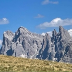
The Sirente: a long, dolomite-like massif spanning for over 12 km along the North-western side, with names of mysterious origin: canalone Scurribile, valle Lupara, Peschio Fracido, Inserrata, Majori, coming down to the wide forested areas embracing the mountain below. We fly over the majestic rock walls, where the sites of pristine glaciers can be seen, while searching for the neviera, located at an altitude of 2000 meters, among the crests and the many peaks down along the two so different sides: in the north-west the mountain drops for 700 meters down to the Middle Aterno and the Subequana Valley; to the South-West, with a long curve, slopes gently to the wide Fucino area. The exploration continues, with a wide turning we try to fly parallel to the massif, in spite of a powerful front wind from the mountain top that shakes the plane; while leaning out of the plane window to take photographs, in spite of warm protections, my hands start freezing.
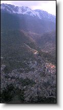
We fly downward to an altitude below the top of the Sirente. The deep scars were made by glaciers during the last Pleistocene glaciation. The rock walls show the erosion caused through millions of years by the weather. We fly above gravelly “cence” covered in snow, where the soil is more brittle, whereas the sturdy rock towers are harder and more resistant to erosion. The fog enveloping the Sirente clears, and we aim at the town of Secinaro, the highest settlement at the foot of the great mountain, and the heart, so to say, of the Sirente.
We fly over the historical town of Secinaro and the Sirente mountain. On top of a mountain crest where the “poggio” rises, on the spot where in the Middle Ages there was the ancient castle of Secinaro, and centuries later the church of San Nicola was built; the village dominates the whole Subequana valley. The roads with inserted rows of flintstones allowed the easy passage of the mules from the living quarters through the “Via della Valle” towards the spot called “Sacco Sirente”, which was reached after two hours, and where the mule owners were able to load the mules with timber or the Sirente ice.
From Secinaro and also from Gagliano Aterno the ice workers left with their mules, employing up to three hours to get out of the woods and finally had to climb up the steep path opened to that purpose along the gravelly gully (brecciaio) up to the neviera site, at an altitude of 2000 meters, where they started to cut ice blocks. In Secinaro I met Luigino Barbati, a Townhall employee whomanages with brothers Sandro and Mario a tourist resort in the area. And it is in Secinaro that I was their guest and established a kind of base camp for the many trekking explorations of the natural landscape of the Sirente range.
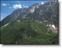
The majestic Sirente mountain hovers above us, while we trek through the thick forest, at the foot of the rocky walls, inside the rugged canyons and the terrain depressions that were once mule paths. We observe the trace of an ancient path now almost covered by the vegetation that “reclaimed it”; even the surface rocks were sawed to allow the passage of the mules loaded with firewood, charcoal and ice. We are well advanced into the spring season, but some snow streaks still persist along the Northern Sirente side, owing to the low temperatures and the sun position at this time of the year, that does not allow the sun rays to reach the area. The buds of the beech-trees have blossomed in just a few weeks: a new life cycle starts in the forest.
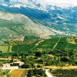
This Sirente photo was taken in the area called “Piano di Jano”, a long plateau where the hamlet of “Pagliare di Tione” is located, inside the Sirente – Velino regional park, extending for over 60,000 hectares, 20,000 more than the better known Parco Nazionale d’Abruzzo, Lazio and Molise. The territory of the Sirente – Velino Park borders the Fucino Plain to the South, Latium to the west, and the Aterno valley to the North and North-West. It includes the Altopiano delle Rocche, the Middle Aterno Valley, the Valle Subequana and Southern Marsica, areas of great historical, cultural and environmental diversity.
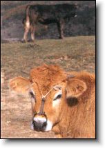
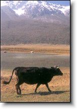
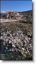
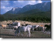
The pastures high up in the Sirente meadows called “Prati Canale” where waters are collected giving origin to a small lake. The Sirente range, with its valleys and canals created by ancient glaciers, includes five important gravelly canals (“brecciai”): Valle Inserrata or Canale Majori, Valle Lupara, Valle Neviera, the Canalone of San Vincenzo and Monte Canale, coming down to the forests, which in their turn cover an area from an altitude of 1100 to 1800 meters. We leave the forest and proceed along the carsick plains, where groups of horses and cows are grazing. One of the cows has on its head an iron gadget, called “frocette” or “nasiera”, which forbids nursing. In this area, a breeder tells us, until the 1970’s also sheep were grazing.
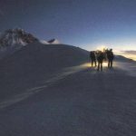
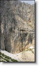
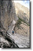
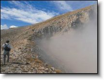
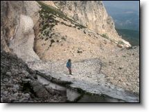
This is the summit of the Sirente range, with its many peaks. We have been walking for hours, and now we are trekking among the peaks following one another at different heights; we go as far as the borders of the canals, once the sites of very ancient glacier circles. We are searching for the brecciaio and with it, the neviera valley. Fog starts rising from the Northern Sirente wall; we must find a passage, an opening to get down into the canal, climb down of an altitude of around 600 meters and reach the neviera site.
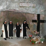
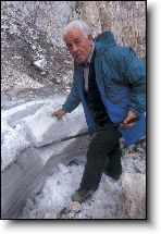
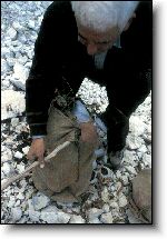
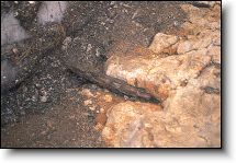
Here is the Sirente neviera, which we finally reach after many hours’ trekking. The site description corresponds to the reports in the ancient papers in the 1874 historical archive of Secinaro, where the “Valle Serrata” is described, a narrow valley enclosed by steep rocky walls 500 meters high. The valley throughout is a wide gravelly area (“brecciaia”) owing to the debris piled up in the centuries as far as the forest border, for a length of 500 meters and a width of 200. At the highest point in the valley the “neviera”, just below a rocky wall, is really impressing, as it is always discharging, as temperature changes, coarse gravel and rocks, which have slowly formed a hump protecting the neviera from the sun and winds. Its position to the north keeps the ice there also in the summer months, so that it can be cut and taken down to the valley by convoys of mules.
The Sirente neviera: a stream of ice 55 meters long, 6 meters wide, located between a vertical rock wall and a deep ditch. We have to move very carefully. With a threatening noise similar to gunshots the mountain discharges debris and rocks with astounding force. We have to lean against the rock wall for shelter, to avoid being hit.
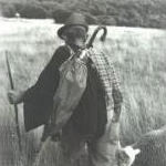
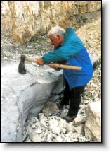
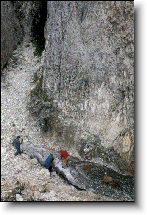
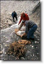
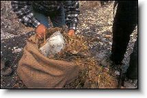
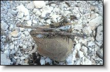
We are back to the Sirente neviera. This time in the company of Luigino Barbati and an elderly ice worker, born in Secinaro. From the glacier’s front cutting begins with an axe. The ice blocks must be all the same size, of about 50-60 kg each. The mule can carry up to 200 kg ice, but only if well balanced, on both sides of the animal’s pack-saddles. We have to be fast, we cannot stay below the rocky wall for too long because of the debris falling down. The ice block must be well worked and smoothed, all blocks in the same form and size, to be delivered to hospitals, markets, rich mansions… Temperature is dropping, it is freezing cold. The ice extraction is performed also with a number of different iron tools.
The ice blocks are covered with “pula” (pula is the powder left from threshing) and then a layer of dry beech leaves and finally enclosed in a sack. This was a kind of heat isolation allowing to maintain about 50% of the product during the long journey to the delivery sites. The ice was measured in “salme”, corresponding to about 100 kg. The ice workers tell how they hit with their axes on the ice, to drive away the “ciaule” (crows) who flew down and stopped on the rock wall called “peschio”, since they might cause real landslides. They would leave Secinaro in the night, so that at dawn they were at the neviera, began to work the ice and then left directly for Apulia, Latium, the towns of the Abruzzese coast, traveling with their mules all day and the following night to finally deliver their shipment.


 Articoli per il quotidiano IL CENTRO
 Il Passaggio nell'Arcolaio, Storie