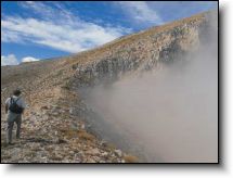
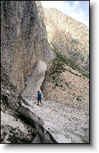
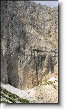
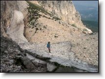
Here is the Sirente neviera, which we finally reach after many hours' trekking. The site description corresponds to the reports in the ancient papers in the 1874 historical archive of Secinaro, where the "Valle Serrata" is described, a narrow valley enclosed by steep rocky walls 500 meters high. The valley throughout is a wide gravelly area ("brecciaia") owing to the debris piled up in the centuries as far as the forest border, for a length of 500 meters and a width of 200. At the highest point in the valley the "neviera", just below a rocky wall, is really impressing, as it is always discharging, as temperature changes, coarse gravel and rocks, which have slowly formed a hump protecting the neviera from the sun and winds. Its position to the north keeps the ice there also in the summer months, so that it can be cut and taken down to the valley by convoys of mules.
Ecco la neviera del Sirente, raggiunta dopo molte ore di cammino. La descrizione del luogo coincide con gli antichi carteggi ritrovati nell'archivio storico di Secinaro, datati 1874, dove si illustra la "Valle Serrata", una stretta valle, racchiusa, e circoscritta da balze rocciose a picco con un'altezza di circa 500 metri. La lunghezza della valle diventata un'immensa brecciaia per il materiale detritico che si è accumulato nel corso dei secoli fino al limite del bosco è di 500 metri, mentre la sua larghezza è di 200 metri. Alla sommità della valle, la neviera, sotto una parete, ci impressiona, perché scarica di continuo, con i cambiamenti di temperatura, forte brecciame e blocchi di roccia che nel tempo hanno formato una gobba che protegge la neviera dal sole, dai venti. Esposta a nord, fa sì che il ghiaccio resista nei mesi estivi per essere tagliato e portato a valle dalle carovane di muli.